South Africa – Flora, Geology & Climate
The diverse South African floral kingdom – the Capensis
Over the course of time, the flora of our planet continuously adapted to the prevailing climate conditions and developed depending on its habitat. The species composition in the various regions of the Earth is shaped by climate, geological development and conditions and the resulting barriers, which cause geographical isolation.
The South African Cape, Australia, the Antarctic and the southernmost reach of South America all used to belong to the southern continent of Gondwana, which broke apart during the Mesozoic millions of years ago. Africa separated from Australia 220 million years ago, and this separation is still reflected in the distribution of related species to this day. Certain South African plants are more closely related to the Australian flora than to that of South American and tropical Africa.
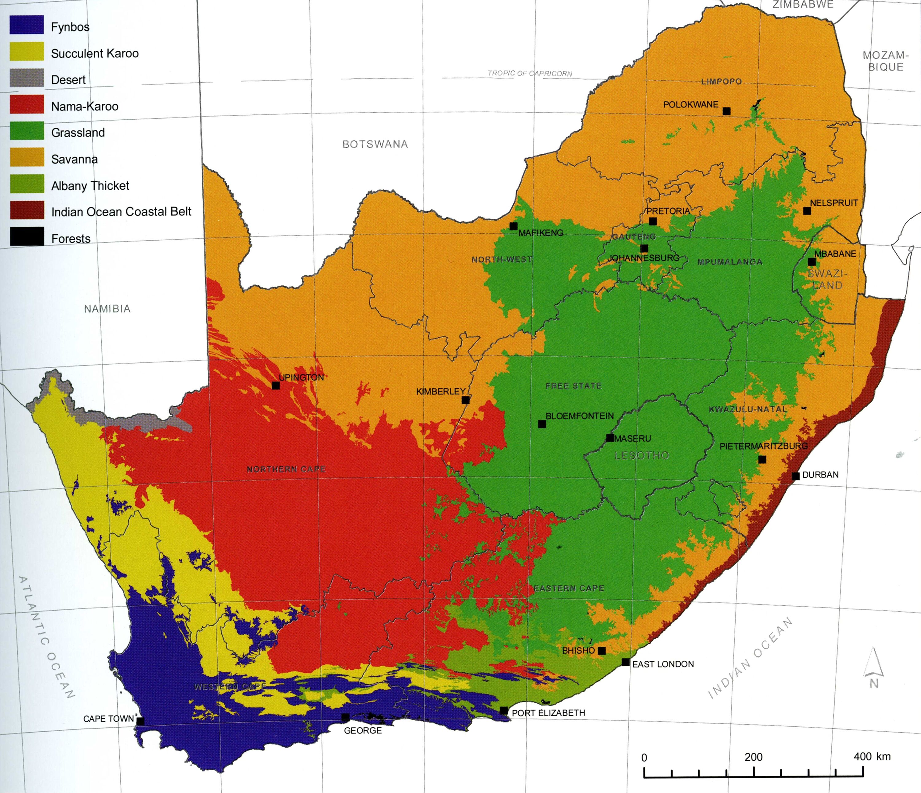
The biosphere is composed of seven floristic kingdoms: the Oceanic Kingdom, the Holarctic Kingdom, the Neotropical Kingdom, the Paleotropical Kingdom, the Australian Kingdom, the Antarctic Kingdom and the South African Kingdom. The latter is the smallest and the only one limited to a single country. It is extremely rich in biodiversity with approximately 9,600 species of vascular plants, 70% of which are endemic, meaning that they do not exist anywhere else on the planet. Many of them are limited to a very small area. The prevailing type of vegetation is fynbos, which makes up 90% of species in this floral kingdom. The other biomes of the Cape are: Succulent Karoo, forest, shrubland, grassland, savannah, Nama Karoo, desert. The diversity of vegetation and its strict separation into very different biomes is due to the special characteristics of South Africa’s geology and climate.
Geological and geographical classification
South Africa's landmass is very old. Its geological basement used to form a part of the southern continent of Gondwana, which broke up between 300 and 100 million years ago. The geological processes set in motion then lasted millions of years and ultimately created today's relief.
South Africa is surrounded by a mountain ridge, the Great Escarpment, to the west, south and east. The country's interior is a trough-shaped plateau called the Highveld (900–1,700 metres), which gradually slopes downwards to the endorheic Kalahari Basin. In the east, the Great Escarpment reaches an altitude of nearly 4,000 metres. Its highest elevations in the south and west are about 2,000 metres tall, and it plunges steeply towards the coastal plain.
Most South African rivers have their source in the Drakensberg and flow eastwards to the Indian Ocean. Only the country's longest river, the Oranje (1,860 km) flows to the west to join the Atlantic Ocean. All rivers experience substantial water level fluctuations.
Climate
The climate of the South Africa regions depends on their altitude and proximity to the ocean. Large swathes of the country are located in the subtropical zone, but many regions experience lower temperatures than other areas at a similar latitude. At the west coast, the cold Benguela Current brings mild temperatures and low precipitation, which has led to the creation of a coastal desert.
Even in midsummer, the central plateau rarely experiences heat of more than 30°C due to its altitude (Johannesburg is located at 1,753 metres above sea level). In winter, temperatures drop to freezing. Only the coastal regions stay a little warmer.
As the surrounding mountain chains act as a barrier for precipitation, the Highveld receives little rainfall, and the Karoo is a semi-desert. Most rains occur in the summer months; only the Western Cape has rainy winters. The coastal plain is between 20 and 250 km (in the Lowveld area) wide. Near the Indian Ocean, rainfall is plentiful, and the soil is fertile.